Friday, October 21, 2022 | 9:00 am - 12:00 pm CDT
Hybrid: Online & Northrop, Best Buy Theater
FREE and Open to the Public (Registration Requested)
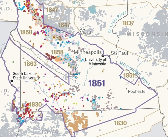
CURA's Community Geographic Information Systems (CGIS) program and the Resilient Communities Project (RCP) are partnering with the Institute for Advanced Study, U-Spatial, University of Minnesota Libraries, and DASH to present this year's “Thinking Spatially Symposium: Indigenous Mapping.” Former CURA CGIS Graduate Research Assistant Kyle Malone is presenting on the storymap “Towards Recognition and University-Tribal Healing (TRUTH),” a strategic analysis of the Morrill land grab in Minnesota. In addition to Kyle's work on the TRUTH project, two RCP Fellows, Madison Bozich and Shuping Wang, contributed to the TRUTH project.
Join us at the 5th annual Thinking Spatially symposium as we explore the topic of Indigenous mapping and cultural connection to place. Maps are most often seen as documents of truth that describe where and what geographic features are by ways of symbolization and textual labels. We make assumptions that maps are wholly factual documents, but they too are a subjective creation. What is the map not telling us and to whom does this concern? Join us as we confront historical truths and explore the use of maps to better understand the dispossession of Indigenous communities as a result of the University land-grab that took place following the Morrill Act and how the simple impact of labeled geographic locations impacts entire communities.
Presented by the Institute for Advanced Study, U-Spatial, University of Minnesota Libraries, and DASH. In partnership with the Center for Premodern Studies; Center for Urban and Regional Affairs; Department of Geography, Environment and Society; Department of History; Mellon Environmental Stewardship, Place, and Community Initiative.
This year’s Symposium will also be live streamed at the North American Cartographic Information Society’s (NACIS) annual conference, taking place in Minneapolis, October 19–22, 2022.
Featured Presenters
- Kyle Malone, presenting the storymap “Towards Recognition and University-Tribal Healing (TRUTH),” A strategic analysis of the Morrill land grab in Minnesota
- Marlena Myles, presenting Dakhóta Thákhočhe (Dakota Land Maps), which illustrate the story of the past, present and future of Dakota people and our language in our traditional homelands
- An Garagiola, Audrianna Goodwin, and Kyle Malone (TRUTH Project) in conversation with cartographer Margaret Pearce about the Land-Grab Universities project and the ongoing work of the TRUTH Project
